Climate zoning of Mayarí municipality based on Lang index
Article Sidebar
Main Article Content
Abstract
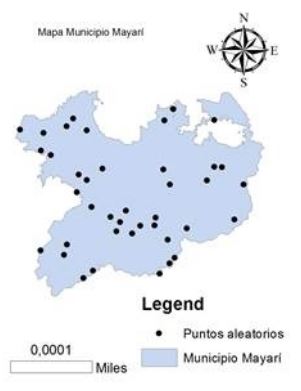
The objective of the research was the climatic zoning of the Mayarí municipality; Lang Index was the estimation by use of data from meteorological station and WorldClim 2. The monthly images of precipitation and average temperature provided by WorldClim 2 were used with a spatial resolution of 30 seconds in the system of WGS 1984 EPSG coordinates: 4326. The images were processed in ArcGIS 3.10 software; and in the Raster Calculator option, Lang Index was obtained. For the extraction of the values, a representation of 40 random points was made that covered the entire region under study, separated at a distance of 10 km. It was determined by linear regression in the STATGRAPHICS Plus 5.0 software; the relationship between Lang Index estimated by WorldClim 2 and that calculated with data from the Guaro meteorological station located in Mayarí municipality. The use of WorldClim 2 showed the existence of three climatic zones (arid, semi-arid and semi-humid). Its estimation had a high determination and correlation for the calculated values of said index, which allows it to be used in territories where there is a low number of meteorological stations for taking climatic data.
Article Details

This work is licensed under a Creative Commons Attribution-NonCommercial 4.0 International License.
Those authors who have publications with this journal accept the following terms of the License Attribution-NonCommercial 4.0 International (CC BY-NC 4.0):
You are free to:
- Share — copy and redistribute the material in any medium or format
- Adapt — remix, transform, and build upon the material
The licensor cannot revoke these freedoms as long as you follow the license terms.
Under the following terms:
- Attribution — You must give appropriate credit, provide a link to the license, and indicate if changes were made. You may do so in any reasonable manner, but not in any way that suggests the licensor endorses you or your use.
- NonCommercial — You may not use the material for commercial purposes.
- No additional restrictions — You may not apply legal terms or technological measures that legally restrict others from doing anything the license permits.
The journal is not responsible for the opinions and concepts expressed in the works, they are the sole responsibility of the authors. The Editor, with the assistance of the Editorial Committee, reserves the right to suggest or request advisable or necessary modifications. They are accepted to publish original scientific papers, research results of interest that have not been published or sent to another journal for the same purpose.
The mention of trademarks of equipment, instruments or specific materials is for identification purposes, and there is no promotional commitment in relation to them, neither by the authors nor by the publisher.
References
Hernández-Cerda ME, Ordoñez-Díaz M de J, Giménez-de Azcárate J. Análisis comparativo de dos sistemas de clasificación bioclimática aplicados en México. Investigaciones geográficas. 2018;(95):1-14. doi:10.14350/rig.57451
Alessandro O, Nyman P. Aridity indices predict organic matter decomposition and comminution processes at landscape scale. Ecological Indicators. 2017;78:531-40.
Pineda-Santos LD, Suárez-Hernández JE. Elaboración de un SIG orientado a la zonificación agroecológica de los cultivos. Revista Ingeniería Agrícola. 2014;4(3):28-32.
Grove AT. Climatic classification: concepts for dry tropical environments. International Crops Research Institute for the Semi-Arid Tropics: Climatic classification: a consultants’ meeting, 14-16 April 1980. 1980;1-5.
Ferrelli F, Bustos ML, Piccolo MC, Cisneros MAH, Perillo GME. Downscaling de variables climáticas a partir del reanálisis NCEP/NCAR en el sudoeste de la provincia de Buenos Aires (Argentina). Papeles de Geografía. 2016;(62):21-33. doi:10.6018/geografia/2016/239051
Zhang Y, Qu H, Yang X, Wang M, Qin N, Zou Y. Cropping system optimization for drought prevention and disaster reduction with a risk assessment model in Sichuan Province. Global Ecology and Conservation. 2020;23:e01095. doi:10.1016/j.gecco.2020.e01095
Tsiros IX, Nastos P, Proutsos ND, Tsaousidis A. Variability of the aridity index and related drought parameters in Greece using climatological data over the last century (1900-1997). Atmospheric Research. 2020;240:104914. doi:10.1016/j.atmosres.2020.104914
Ferner J, Schmidtlein S, Guuroh RT, Lopatin J, Linstädter A. Disentangling effects of climate and land-use change on West African drylands’ forage supply. Global Environmental Change. 2018;53:24-38. doi:10.1016/j.gloenvcha.2018.08.007
ONEI. Anuario Estadístico de Mayarí 2018. Habana; 2019. 16 p.
Fick SE, Hijmans RJ. WorldClim 2: new 1-km spatial resolution climate surfaces for global land areas. International Journal of Climatology. 2017;37(12):4302-15. doi:https://doi.org/10.1002/joc.5086
IGAC (Instituto Geográfico Agustín Codazzi). Instructivo. Zonificación climática grupo interno de trabajo de levantamientos agrológicos. Cód. I40100-05/1 4.V1 [Internet]. 2014 p. 10. Available from: https://repositorio.uho.edu.cu/bitstream/handle/uho/8854/Osman%20A%20Vel%C3%A1zquez%20S%C3%A1nchez.pdf?sequence=1&isAllowed=y
Luján-Bustos M, Ferrelli F, Piccolo MC. Estudio comparativo de tres modelos climáticos en Argentina. 2017;40(1):34-43. doi:10.11137/2017_1_34_43
Batista P-D, Dámaso R. Algunas consideraciones sobre el comportamiento de la sequía agrícola en la agricultura de Cuba y el uso de imágenes por satélites en su evaluación. Cultivos Tropicales. 2016;37(3):22-41.
Vema V, Sudheer KP, Chaubey I. Fuzzy inference system for site suitability evaluation of water harvesting structures in rainfed regions. Agricultural Water Management. 2019;218:82-93. doi:10.1016/j.agwat.2019.03.028
Fraga H, Guimarães N, Santos JA. Future changes in rice bioclimatic growing conditions in Portugal. Agronomy. 2019;9(11):674.
Calci Quispe BE. “Aplicación de modelos climáticos globales para la caracterización climática en la microcuenca de la Laguna de Chacas y sus Proyecciones de cambio Climático al 2050 y 2070” [Internet]. [Perú]: Andina Néstor Cáceres Velásquez; 2018. 89 p. Available from: https://alicia.concytec.gob.pe/vufind/Record/UANT_f44a3f4846e0624b23a572e08e20a203/Details
Poggio L, Simonetti E, Gimona A. Enhancing the WorldClim data set for national and regional applications. Science of The Total Environment. 2018;625:1628-43. doi:10.1016/j.scitotenv.2017.12.258
Casa-Martín F da, Echeverría-Valiente E, D’Amico FC. Zonificación climática para su aplicación al diseño bioclimático. Aplicación en Galicia (España). Informes de la Construcción. 2017;69(547):e218-e218. doi:10.3989/id55319